Central Space Agency
Central Space Agency is a pioneering organization dedicated to advancing Space Situational Awareness (SSA),
Space Domain Awareness (SDA), Space Intelligence, Space Traffic Management, Autonomous Systems and Space
Downstream Solutions. We are at the forefront of developing cutting-edge solutions that enhance the security,
safety and efficiency of space operations, spanning real-time satellite monitoring, predictive analytics,
AI-driven intelligence and advanced platforms for space data fusion and visualization.
Our innovative technology integrates artificial intelligence, data fusion and advanced analytics to monitor,
protect and optimize space assets in an increasingly complex and contested environment. Our mission is to push
the boundaries of space technology by leveraging cutting-edge AI and cloud technologies, along with intelligent
software solutions, to not only enhance the security, efficiency and sustainability of space operations but also
to foster responsible and autonomous systems that support global space activities for the long term.
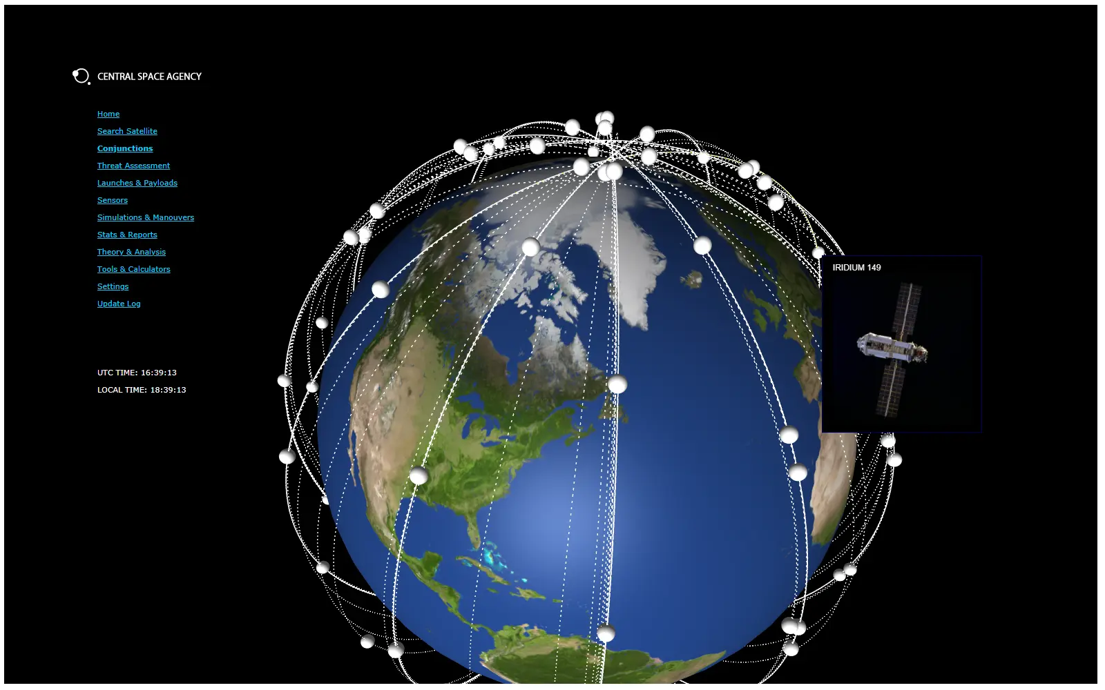
Highly Accurate Catalog
The single most valuable asset in any Space Situational Awareness (SSA) operation is a highly accurate, high-quality orbital catalog. Without precise, reliable and up-to-date information about every object in the region of space you are responsible for — its past positions, current location, velocity, when and where it was last observed, and how certain those observations are — even the most advanced algorithms, the fastest computers, and the most experienced analysts cannot deliver trustworthy results. An SSA catalog is not a static database; it is a dynamic, living system that must be continuously refreshed with new sensor tracks, measurements, and observations from radars, telescopes, and other sources worldwide. At the same time, it requires constant refinement through sophisticated correlation, association and validation processes to correctly link new data to existing objects, eliminate duplicates, and resolve ambiguities. The accuracy, completeness and timeliness of this catalog directly determine the quality of every downstream service: conjunction assessments, collision avoidance maneuvers, anomaly detection, re-entry predictions, and space traffic coordination. A catalog with gaps, outdated orbits, or misassociated objects inevitably leads to false alarms, missed warnings, or unnecessary maneuvers that waste fuel and operational time. Conversely, a catalog that is meticulously maintained, regularly updated and enriched with the best available data empowers operators, satellite owners, and defense organizations to make confident, informed decisions. In short, everything in modern SSA promises — safer satellites, sustainable orbits and responsible space operations — rests on the strength and precision of that one foundational element: the catalog.
Assess Vulnerability & Protect Assets
Assess Vulnerability & Protect Assets
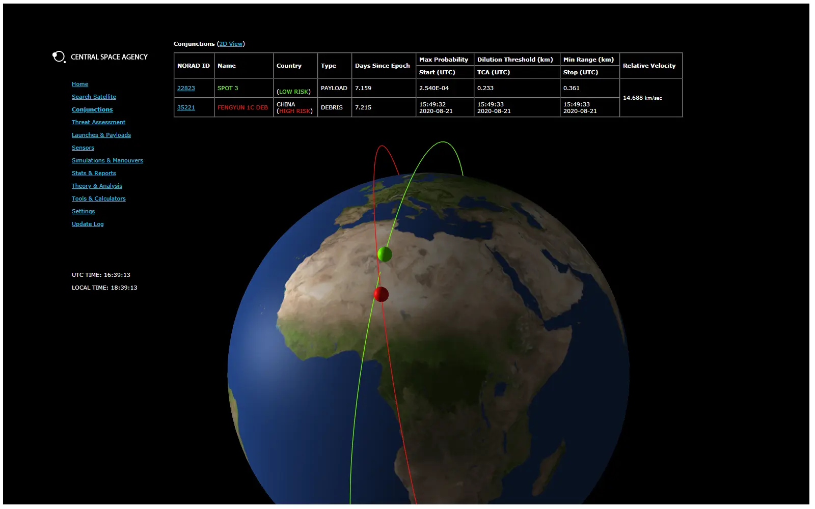
Gain immediate, actionable insight into the real risk posed by any threat object — whether active satellite, debris, or hostile payload — and receive highly customized alerts paired with in-depth vulnerability assessments tailored to each of your assets. This powerful capability lets you run a full vulnerability analysis in seconds, simultaneously across your entire fleet or constellation, regardless of size, delivering true end-to-end mission assurance for even the most complex space-based systems.
The analysis covers every orbital regime and every possible interaction scenario: LEO-to-LEO conjunctions, GEO-to-GEO close approaches, cross-regime LEO-to-GEO threats, highly elliptical orbits, cislunar space, and everything in between. It automatically accounts for differing atmospheric drag effects, solar radiation pressure, maneuver capabilities, and positional uncertainty so that risk scores and recommended actions remain accurate and reliable across all altitudes and inclination bands.
Performance
As the number of objects in orbit continues to grow exponentially — from active satellites and rocket bodies to millions of pieces of debris — the computational demand required to track, propagate, and analyze every fragment rises dramatically. Traditional systems quickly reach their limits, suffering significant slowdowns or requiring massive, costly infrastructure upgrades.
Magnus changes that equation entirely. Designed from the ground up for extreme scale, it routinely processes and maintains high-fidelity orbital data for more than 200,000 resident space objects — including untracked and newly discovered fragments — while delivering near-real-time results with only minimal impact on performance. This breakthrough efficiency means operators no longer have to choose between catalog completeness and system responsiveness: Magnus provides both, ensuring accurate conjunction predictions, timely alerts, and reliable decision support even as the space environment becomes ever more crowded.
More Modules!
Expand your operations with additional Modules.
Modules deliver powerful, specialized capabilities that go far exceed basic tracking and awareness. From large-scale automated data analysis and advanced pattern-of-life monitoring to real-time collaboration tools, multi-user mission planning, automated maneuver optimization, and customizable reporting workflows, each module is designed to solve real operational challenges and streamline decision-making.
Activating a module instantly unlocks new, mission-critical abilities tailored to your specific needs — whether you’re managing a commercial mega-constellation, operating a national security payload, or coordinating international space traffic. With every module you enable, your platform becomes smarter, faster, and more autonomous, turning raw data into clear, actionable advantage.
Collaborate
Secure SSA Data Sharing
Our Collaboration Module transforms the way space operators share critical Space Situational Awareness (SSA) data by making it fast, secure, and fully auditable. The module enables trusted parties — whether commercial constellation owners, government agencies, or international partners — to exchange high-precision orbital data, conjunction warnings, maneuver plans, and sensor observations with complete confidence.
Every transaction is cryptographically signed, time-stamped and immutably recorded while fine-grained access controls ensure sensitive information is only visible to authorized users. The system supports both one-to-one secure exchanges and many-to-many data-sharing coalitions, all without requiring operators to surrender custody of their proprietary data. The result is a new standard in responsible, transparent, and secure collaboration that dramatically improves collective space safety and situational awareness — all while protecting each participant’s operational security and commercial interests.
Orbital congestion is rapidly becoming a growing problem as more than two dozen companies alone have proposed launching well over 20,000 satellites in the next 10 years...
Simulations & Strategic Insights
Advanced Mission Planning & Long-Term Risk Simulation
Theorem is our powerful simulation engine designed to support mission planning and strategic decision-making for both current operations and future constellations. By modeling complex orbital scenarios over months or years, Theorem enables operators to evaluate constellation designs, deployment strategies, rendezvous sequences and end-of-life disposal plans with unprecedented depth and realism.
Gain critical insights into long-term orbital evolution, constellation performance under varying environmental conditions and potential conflicts with other national or commercial mega-constellations. Theorem reveals hidden risks that are easily overlooked in early planning stages — such as cumulative drag effects in low orbits, gradual phasing mismatches, or emerging congestion hotspots — and benchmarks your plans against global trends and international operator behaviors.
With flexible “what-if” simulations, covariance-realistic propagation and detailed perturbation modeling, you can confidently compare design alternatives, optimize launch windows, assess regulatory compliance risks, and ensure sustainable operations from day one. Theorem transforms uncertainty into strategic advantage, helping you build and operate resilient constellations in an increasingly competitive and crowded orbital environment.
A growing number of countries and commercial actors are getting involved in Space, resulting in more innovation and benefits on Earth, but also more challenges and competition in Space.
Insights
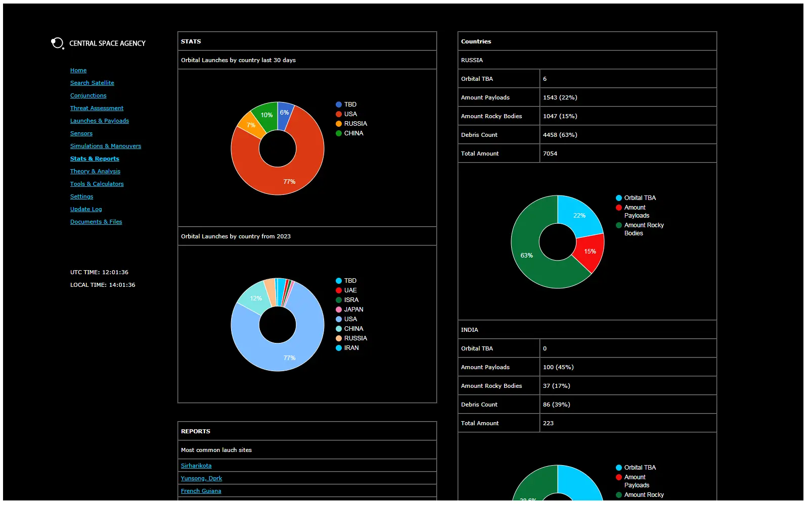
Strategic Statistics & Analytics
Insights – Clear, Actionable Space Statistics at a Glance
The Insights module delivers comprehensive, ready-to-use statistical reports on the global orbital population and key market trends. Leveraging our high-accuracy proprietary catalog, Insights generates instant overviews of satellite distributions by country, operator, orbit regime, object type, launch year, and operational status — perfect for insurers, investors, regulators, and strategic planners.
Get immediate answers to critical questions: How many active satellites does each nation or commercial operator control? Which orbits are experiencing the fastest growth? What are the trends in debris generation and removal? Insights provides customizable benchmarks, fleet comparisons, market share analyses, and risk exposure summaries, all updated daily and presented in clear tables, charts, and downloadable reports.
Whether assessing insurance portfolios, evaluating market positioning, supporting regulatory filings, or informing investment decisions, Insights turns complex orbital data into straightforward, reliable statistics — giving you the strategic intelligence needed to stay ahead in a rapidly evolving space landscape.
Insights breaks and fuses information into comprehensible reports for technical or executive review.
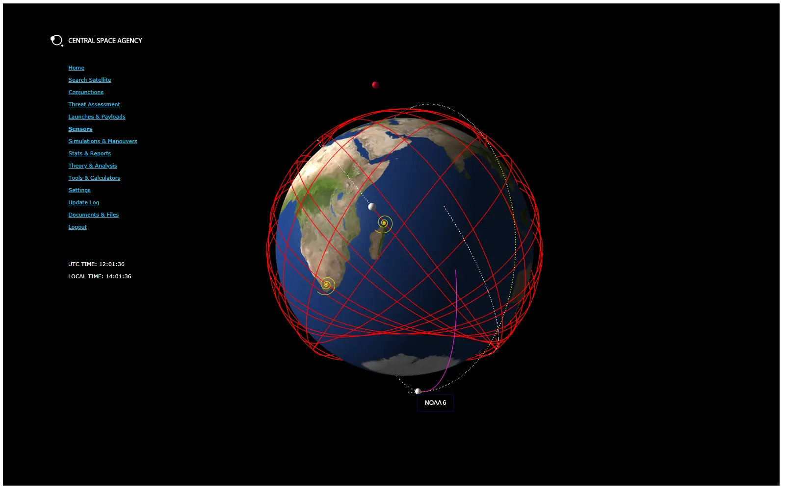
Sense
Global Sensor Network
Ultra-Low Latency Tracking
Sense delivers dramatically superior orbit accuracy and richer situational awareness through continuous, high-quality observations and geographically diverse network of optical telescopes and radio sensors. Spanning multiple continents, this infrastructure ensures 24/7, all-weather coverage and generates independent measurements daily — on both cooperative and non-cooperative objects across all orbital regimes.
The key advantage lies in latency and diversity: by directly feeding fresh data from multiple sensors into our catalog within minutes, we eliminate the delays inherent in public or third-party sources. This multi-sensor approach not only fills coverage gaps but also enables cross-validation, resulting in smoother, far more precise orbital paths with uncertainty often an order of magnitude lower than public catalogs.
Operators benefit from earlier, more reliable conjunction detection, drastically fewer false alarms and greater confidence in collision avoidance decisions. With Sense, you gain a decisive real-time edge — free from reliance on outdated or limited external data — keeping your assets safer and your space operations fully under control.
Our Sensor network collaborates with a vast number of ground-orbital surveillance stations to track unknown space objects.
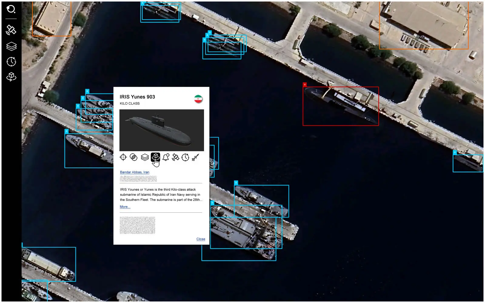
Horus
Geospatial Intelligence
Make Smarter Decisions with Daily Intelligence Reports
Stay ahead of emerging threats and opportunities with concise, actionable daily intelligence reports that focus on your specific areas of interest. Our automated system continuously gathers, cross-validates, and fuses open-source intelligence (OSINT), imagery intelligence (IMINT) and curated human intelligence (HUMINT) from trusted industry and government networks.
Whether detecting unusual maneuver activity or assessing broader orbital behaviors, our platform fuses open-source data — such as public announcements, catalogs and operator statements — with precise Earth Observation imagery. This approach provides critical context for fact validation, reliable classification of space objects and activities, and early insight into potential risks, giving you a clear informational edge for faster and more confident decision-making.
Horus offers a comprehensive and user friendly all-in-one solution to better understand areas of interest.
Contact us
Are you interested in exploring how our advanced sensor fusion and situational awareness platform can support your objectives — whether in aerospace, defence, aviation security, research, or emerging multi-domain applications? We would be delighted to hear from you, whether you wish to request a personalized demonstration, discuss collaboration or membership options, explore partnership opportunities or share innovative ideas, research papers or project proposals aligned with our expertise in sensors, radar systems, data integration and resilient sensing technologies. Please don’t hesitate to reach out — we look forward to starting the conversation.